
2.1.12 Bird-borne tracking
Probably not relevant for Palau at this point.
For experts only
There are three different types of technologies used for tracking seabirds, VHF radio, Global Positioning System (GPS), Platform Transmitting Terminal (PTT) and Global Light Sensor (GLS). Choosing the best technology and device will depend on the purpose of your tracking project and the size of the species you are studying. A variety of methods are used to attach the devices to the birds, taped to back or tail feathers, chest and leg harnesses, and suturing (this section below). General best practice is for the tag weight not to exceed 3% of body weight to minimise the impact of carrying additional weight. Be aware that any attachment will have some impact on a bird’s behaviour. This section serves as an introduction to tracking and provides examples (case studies) of tracking projects using different types of devices.
It is important to note that with every method there are risks, and that the bird’s health should always be paramount and a primary consideration. Furthermore, it must be stressed that birds should never be captured or handled unless the people involved have been properly trained in the attachment methods being used, understand safe handling techniques, and are aware of how to mitigate any risk to the bird, as well as having the appropriate permitting in place. If you do not know how to catch or handle birds, contact experts in the field and arrange for training sessions. If you do not know what the laws are related to capturing and tracking birds for scientific purposes, or what permits may be needed, do your homework first!
Telemetry – VHF and UHF radio transmitters (tags)
Radio is an excellent type of signal to use when tracking animals, in part because radio waves can transmit information rapidly and through long distances in air. In order to track a bird using radio technology you need to equip the bird with a transmitter that can send you a signal. This signal will require that you have a receiver that will detect the radio signal sent by the transmitter. Both the transmitter and the receiver use antennas to aid in sending and receiving the animal radio signal. Another significant advance in radio tracking technology has been the miniaturization of the tags.
While radiotelemetry was effective in enabling discovery of New Zealand Storm-petrel breeding sites, it also provided the first data on the species’ breeding biology without major intervention in the fragile breeding habitat and at a time of year when storm-petrels can be sensitive to disturbance. This was achieved by using a remote VHF receiver set up close to the first occupied nest site found, logging visitation by the tagged bird over several weeks.41
In the ten years since 2013, over 500 New Zealand Storm-petrels have been captured on the island, and a mark recapture study has provided a population estimate.42 Their calls have been recorded and used in a social attraction experiment to set up an artificial colony. While the latter has not been successful to date, their overall population appears to be steadily increasing.43
A genomics study was conducted in 2021, comparing the DNA of birds from locations at sea up to 250 kilometres from the island and the Hauraki Gulf, confirming that Hauturu remains the only likely breeding site.44
Hauturu was declared predator-free in 2004, after first cats and then rats were eradicated. Released from predation-pressure, the storm-petrel’s population appears to be increasing. In this case, the survival of a presumed extinct species can be considered an unintended benefit of the coincidental protection of its breeding habitat, knowledge of which was made possible by using the very small 0.67g VHF tags and a major field tracking effort.
GPS tracking studies
Advances in technology have meant satellite tags and data loggers are becoming small enough to be fitted to a wide range of seabird species to provide Global Positioning System (GPS)-level data on their movements45. Both types of tags also often contain solar panels, allowing for extended tracking periods that are not solely relying on the power from a single internal battery. Satellite tags are particularly useful for birds that are likely to range far and for which there is limited to no chance they will be caught again, such as fledglings or birds caught away from burrows. This is because locational data are sent to a satellite and then downloaded onto a computer at your leisure. The limitation of satellite tags is that they give locational fixes at widely spaced intervals over each 24-hour period, meaning that fine-scale movements (such as transit routes over land) are not easily obtained.
Conversely, data loggers give GPS-level locational data on a very fine scale – many tags are capable of taking locational points every minute. However, many data loggers require the bird to be recaptured. This reduces the number of projects they can be used in by restricting them to scenarios where you can be assured that you will recapture the bird (i.e., by tagging them at known burrows). To circumvent this downside, some data loggers are now available with download stations – static devices with antennae that download data to the station as the bird flies past. Others connect into mobile networks allowing positions to be sent through to your phone.
Once data are retrieved researchers are able to plot the latitude and longitude of the bird’s locations and better understand their distributions. Such information can be used for a wide range of scenarios, including identifying key foraging grounds, wintering locations and migratory routes. The data can also be used to assess the birds’ behaviour and the way in which they utilise their surrounding environment.
In some scenarios, data loggers have also been used to back-track transiting birds to locate as-yet unidentified colonies (e.g., Hawaiian Petrel, see Case Study below). In these scenarios, birds flying overhead were attracted to floodlights and spotlights, grounded and then had data loggers attached to them. When tracks of the birds were subsequently collected from the base stations, they were then used to zero in on burrows and successfully locate them.
Methods for attaching tracking devices
Attachment methods will be guided by the type of tag, the behaviour and size of the species in question, and the duration for which you want to collect data. While it is great to have extended data sets spanning a long time period, bear in mind that the additional weight of the tag can have negative consequences for the bird.
If a device is known to impact breeding in any way, it should not be used. No data are worth the losses of individual birds (adults or chicks). If there is some concern that this maybe the case, all devices should be carefully trialled to show there is no impact before a research programme is rolled out.
It is also important to minimize the amount of time the bird is carrying the tag (especially for larger, bulkier devices), so make sure your attachment method reflects this. Additionally, tag attachments are specialised techniques and should only be carried out by people who have received sufficient training to be undertaking the work.
There is a wide range of attachment methods for the tracking devices outlined above. Any attachment must not be attempted without attendance, at the time of first applications, by a person previously experienced in the method. Common attachment methods include:
- Leg: Particularly used for GLS tags (as they are so light), tags are attached to metal leg bands, plastic colour bands or custom-made devices (like Velcro cuffs) via cable ties. Make sure that the cable ties are rated UV stable.
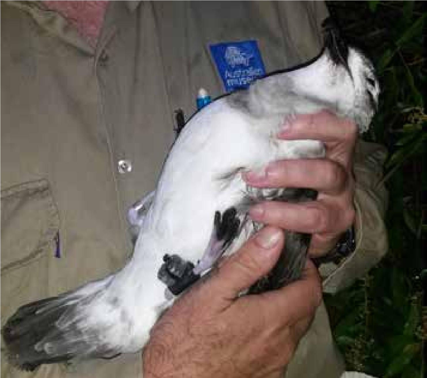
Figure 67. Adult Kermadec Petrel fitted with a Velcro cuff attached GLS device. Photo: Nicholas Carlile.
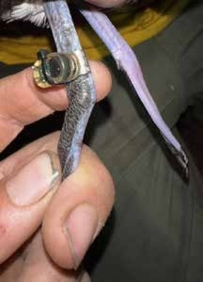
Figure 68. GLS attached directly to the metal band. Photo: André Raine.
- Tail feathers: For seabirds with longer tail feathers, tags can be attached to the central tail feathers, at the base. A classic way to do so is to use TESA tape, which is wrapped around two (or four) central tail feathers and the tag itself. If the tag has a solar panel, make sure the solar panel is not covered by the tape (and that feathers do not obscure the panel either)! A base plate can aid in attaching the tag. If the tail is short, this attachment method could interfere with the bird’s flight ability. Placement should also be made in such a way that the tag is close to the base of the tail to reduce impacts to balance. At the same time, care must also be taken not to impact the bird’s ability to access its preen gland, located above the base of the tail.
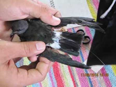
Figure 69. Galapagos (White-vented) Storm-petrel with VHF transmitter taped to central tail feathers before release. The antenna extends beyond tail. Photo: Chris Gaskin
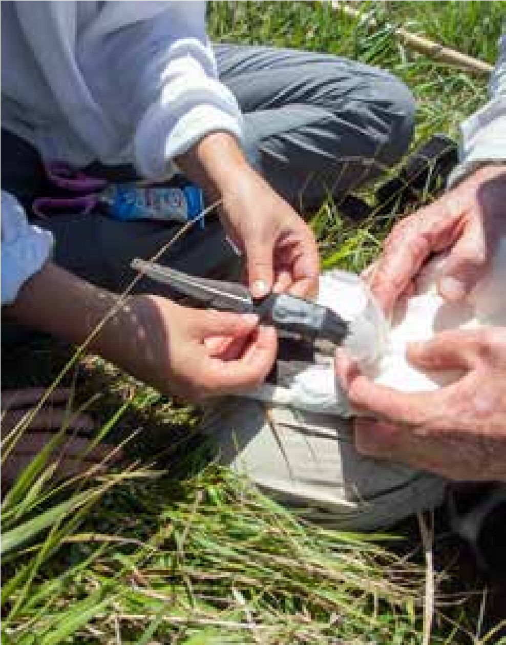
Figure 70. Tail-mounted GPS logger attached to central tail feathers of an Australasian Gannet. Photo: Edin Whitehead.
- Back feathers: Another position for tags is on the bird’s back. As with the previous method, tags are attached to back feathers via TESA tape. This position keeps the tag in a central position, reducing the chance that the tag weight will affect the bird’s balance and flying ability. In this scenario, sufficient feathers should be used to keep the tag in place. Bear in mind that when the tags eventually come off, the glue from the tape may have an impact on the waterproofing of the bird’s back feathers.
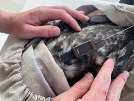
Figure 71. GPS logger attached to the back feathers of a Balearic Shearwater with TESA tape. A base plate has been glued to the bottom of the logger in this case to facilitate attachment. Photo: Chris Gaskin.
- Harness: Harnesses are a more specialised method, where the tag is mounted on a harness (made from Teflon ribbon or similar) and then the harness is attached to the bird. Harnesses often fit over the bird’s shoulders and hold the tag in place on the back, or they can be looped over the bird’s thighs. Harnesses that are used on seabirds that dive, must be fitted to ensure they do not slip over the bird’s wings during diving and entangle the bird in the process. Harnesses can be made to stay on the bird for years, or they can have a link, or threads woven into them that are designed to snap after a certain amount of time, allowing the tag to eventually fall off. Please note: Harnesses should only be used by seabird researchers with experience in this technique as they are more risky than other attachment methods
- Suturing: Another very specialised attachment method, suturing involves attaching the tag to a bird’s back via the application of multiple surgical sutures. With this method, the tag is stitched into the bird’s back, with the sutures sliding under the birds skin. This attachment method should last longer than tags attached via tape, allowing for longer tracking time periods. Sutures designed to dissolve over time assure the tag will fall off if the bird is not recaptured and tag removed. Even with non-dissolvable sutures, eventually the movement of the bird results in the suture snapping and the tag falling off. Please note: Suturing should only be used by seabird researchers with experience in this technique as it is more risky than other attachment methods.
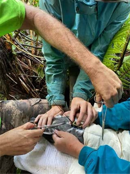
Figure 72. Satellite tag being sutured to the back of a Hawaiian Petrel. Threads are still visible before trimming. Photo: André Raine.
- Passive Integrated Transponder (PIT) tag: Although not a tracking device, another useful piece of technology is the PIT tag. This tiny little tag can be attached to the leg of a bird by either super gluing it to a plastic band or even sealing into a custom 3D printed leg band (such as in the photo below). PIT tags can also be surgically implanted under the skin between the shoulder blades, below the back of the neck. A PIT tag reader is then installed at the mouth of the bird’s burrow. Whenever the bird enters or exits its burrow, the PIT tag is scanned (just like in a supermarket checkout) by the reader, which collects data on the date and time of the entry or exit of the individual. As the PIT tag is uniquely numbered and thus easily cross-referenced with the bird’s metal band number, PIT tags provide information on the burrow activity of a breeding pair throughout the season without the need to continuously check on burrow contents and risk disturbing the bird. PIT readers need constant power supply, so good solar access for panels to supply each unit or group of units is necessary for this to be a useful method.
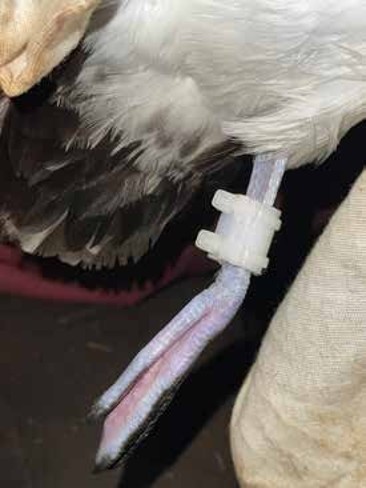
Figure 73. PIT tag attached using a 3D-printed PIT tag holder. Photo: André Raine.
Global Light Sensor (GLS) Tracking studies
Nicholas Carlile, Æstrelata Restorations
Compared to the previous tracking technologies, Global Light Sensor (GLS) technology is significantly less accurate than GPS tracking devices. While GPS devices are accurate to a few meters in many cases, GLS tags provide locational fixes that are more in the range of 150 km, but up to 450 km in some instances.48 They also require the bird to be recaptured to obtain the tag and thus the data. On the upside however, they are relatively cheap and can be produced with a mass as little as 0.5g enabling the smallest species to be tracked at sea. The low cost of the tags also means that more individuals can be simultaneously tracked to gain a population-wide assessment of movements from single or multiple colonies within the same time-period. With the low tag weight (and thus burden to the bird) the same individual can be tracked throughout the year and for several seasons with significantly less stress than a larger tag.
Unlike satellite tags and data loggers, geolocation technology relies on accurate measurements of changes in light intensity, usually at 10 min intervals, to obtain locational data. Depending on the analysis software, this light curve representation can also be used to infer the timing of changes in behaviour of surface-nesting species (whether at-sea, on-island or commencement or ceasing of incubating/brooding behaviour). Alternatively, for nocturnal burrow-nesting species, light level data can also be used to obtain information on burrow attendance patterns (recorded by changes in light levels and sustained periods of dry conditions/stable temperatures). The GLS units are also often fitted with other measuring equipment that can indicate frequency of water immersion, water temperature and sometimes water depth. All data are stored within an on-board microchip.