
2.2.8 Case study - Beck’s Petrel, Silur Bay, southern New Ireland, Papua New Guinea
During an expedition to New Ireland, Papua New Guinea to catch and track Beck’s Petrels and try and locate breeding sites, a sea-watch component was included in this multi-faceted expedition at Silur Bay. This was undertaken to assess whether birds were gathering off shore and transiting to locations inland – data which would then be used to coordinate an attempt to use floodlights to try and capture and attach tags to transiting birds.13

Figure 86. Beach front survey location at Silur Bay, with helpers. Photo: Bill Morris.
A scope (Swarovski with 20-60mm zoom) was set up on the shore, and the bay scanned for Beck’s Petrels. They were counted whenever they were seen. The method used was to do a slow scan every 15 minutes from one side of Silur Bay to the other from 15:00-18:00. Beck’s Petrels were only counted if they were seen below the horizon (i.e., coming closer into the bay). On each afternoon many seabirds were counted on the horizon, but they were too far away for positive identification and were discounted. Total counts by 15 minutes were then tallied (see Figure x). It was found that there was a steady build-up of birds coming closer into the bay as the survey period progressed, with birds milling about in restless flight until the point of darkness. No birds were ever seen flying inland or flying over the camp during daylight hours, however, two to three birds were seen flying overhead in the lights after dark. The results of these surveys were then used to guide the subsequent capture and tracking methods (both at sea and on land) throughout the rest of the expedition.
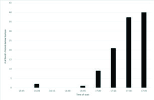
Figure 87. Total counts of Beck’s Petrels by 15 minutes. Source: Beck’s Petrel Expedition 2017 report.