
2.2.7 Drone surveying
Probably not relevant for Palau at this point.
Rohan Clarke and Karina Sorrell, Monash University
Overview
Drones have rapidly advanced wildlife monitoring in recent years. For surface-nesting seabirds that form large aggregations in open terrain, drones are especially useful,62,63 and can be operated safely within breeding colonies.64
Generally, a drone aircraft is flown over the target area of nesting birds along a pre-determined flight route to collect a series of images that look directly down on the colony. The height and speed of the aircraft, image overlap, and camera settings are pre-programmed into the flight plan. Specialised software is then used to stitch images using tie points (points that do not differ between images) to form a single georeferenced orthomosaic image of the entire mapping area.
Tags can then be placed on the orthomosaic to count different species, age classes, and nesting stages (depending on the resolution of imagery). Whilst drone operators are on-ground collecting drone imagery, ground truthing should be undertaken to confirm which species of seabird are present at the site. Ground truthing by experienced seabird observers assists with subsequent species identification and behaviours visible in the collected imagery.
Equipment and flight planning
There are a variety of drone aircraft that are suitable for monitoring seabirds. Lightweight quadcopter aircrafts are well-suited, with current popular models including the DJI Phantom 4 RTK (1.391 kg) and DJI Mavic 3 Pro (0.958 kg) (Dà-Jiāng Innovations (DJI), Shenzen, China). Flights are designed in purposebuilt flight planning software on either the in-built controller screen, or an external tablet. To designate the flight area, a polygon is drawn around the seabird colony area of interest using a satellite image base map as a guide. Flight parameters are set within the flight-planning software. General camera settings for drone flights include Camera gimbal angle -90° (nadir), white balance either ‘sunny’ or ‘cloudy’ (according to the weather conditions at the start of the flight); shutter speed priority fixed at 1/1000 second to minimise image blur; aperture and ISO set to automatically adjust to variable light conditions within the flight; and focus set to infinity. Suitable image capture setting are 90% front- and 75% sideoverlap to allow adequate post-flight generation of orthomosaics.
Survey height is an important consideration for any drone operation, where image resolution, battery limitations, and disturbance to the seabirds and any other wildlife should all be accounted for. Smaller species, such as terns, may require a lower flight height to achieve an acceptable level of image resolution for identification in the final orthomosaic image. However, as outlined in the SPREP document “Responsible Marine Wildlife Viewing Guidelines”, an appropriate flight height above seabird colonies of 50m is recommended. Prior to commencing formal surveys, a trial flight may be required where images are taken at different flight heights to assess image resolution and inform survey flight height.
Topography, vegetation, and seabird nesting behaviour also impact flight planning – specifically survey height. For seabird species that nest on the ground in open terrain, or on top of low vegetation in lowrelief landscapes, a simple flight plan where the aircraft is flown at a consistent height would be suitable. For seabird species that nest in tree canopies, the height between the top of the canopy and aircraft should inform flight height (not the height above ground) to achieve an appropriate image resolution and avoid collisions. Where the topography is highly variable within the survey area (e.g., seabirds nesting in trees in a terraced landscape), a drone capable of terrain tracking should be used to allow mapping with a variable flight height. This method allows the aircraft to maintain a constant height above the ground or tree canopy.
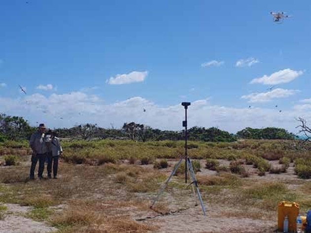
Figure 83. Monitoring a drone flight. Photo: Monash University.
Image processing
Post-flight processing of aerial images should be undertaken in software that is capable of stitching multiple images together e.g., Agisoft Metashape, Pix4D Capture. These software programs automatically align images based on geolocation data and then stitch all images together to produce a final orthomosaic image of the survey area. This orthomosaic can then be used to mark the birds to obtain final counts.
Digital image tagging
Birds may be tagged in orthomosaics using either manual tagging, or automated image recognition. Geographic Information System (GIS) software (e.g., ArcGIS and QGIS), are suitable software packages for manually tagging orthomosaic images. A 10 x 10 m grid (or similar) overlaid on the orthomosaic may aid observers to systematically count grid-cells. However, tagging orthomosaics is a time-consuming task when completed manually. That is, each digital tag that is placed on a bird must be individually positioned and labelled by species and with an optional series of additional attributes that may include nesting status, behaviour, age, sex, etc. With advancements in automatic image recognition, this process is becoming more efficient whereby an algorithm is trained to automatically detect and assign attributes to birds in images.65,66 Ultimately, for drone surveys to be deployed as a practical and efficient tool for the ongoing monitoring of large aggregations of breeding seabirds, automatic detection and identification is critical to the workflow. Small breeding colonies may be counted manually; however, the task becomes onerous once seabird numbers exceed ~1,000. The development of this automatic detection process is underway for some seabird species globally, but for most species is not yet complete and/or publicly available.
Species suitability
Some species cannot be effectively monitored using drone surveys. This may be for a variety of reasons such as behaviour that precludes detection from above (e.g., seabird species that nest underneath vegetation or in burrows) or multiple species that lack identification features that facilitate assignment between similar species from above (e.g., Black Noddy and Lesser Noddy). Ultimately, these species will vary by location and require a case-by-case suitability assessment for drone surveys. Timing of colony formation and breeding will also be an important factor to consider here. For example, two species with similar appearances may not be able to be identified in the same image if they have overlapping breeding seasons. However, if the breeding timing is known and occurs at distinct times of the year, identification may be assumed based on an assessment of timing paired with ground-truthing expert observers at the time of drone surveys.
Benefits
Recent research underscores these benefits with paired drone and ground surveys of Greater Crested Terns and Lesser Frigatebirds in the tropics (and penguins on Sub-Antarctic islands) demonstrating that drones detected more nesting seabirds and improved monitoring precision (i.e., sample variance) by an order of magnitude when compared with traditional methods62. Subsequently, colony counts were demonstrated to be more accurate (i.e., closer to the true population number) than traditional counts using models to mimic seabird colony structures.63
To illustrate the practical application of drones in seabird monitoring, drones now serve as the standard tool for population monitoring at a number of tropical seabird islands in the Indo-Pacific region. Of note are programs to monitor ground nesting Greater Crested Terns which form dense and relatively uniform nesting aggregations (e.g., Great Barrier Reef Islands), shrub and tree-nesting frigatebirds whose colony structure often involves clusters of nests within a broader colony area (e.g., Ashmore Reef), and tree-nesting Red-footed Boobies whose colonies can span many 10s of hectares (e.g., Pulu Keeling). These distinct nesting habitats present different backgrounds in aerial images, which can complicate ground-based counts. However, drone surveys can be readily modified to accommodate these variations, capturing high-resolution images that allow for the correct assignment of species and ultimately monitoring programs underpinned by precise and accurate techniques. A key advantage of drones is that images can be stored and viewed later whereas counts by ground observers depend on the experience of the field team and cannot be verified by future workers.

Figure 84. Nesting Lesser Frigatebirds, West Island, Ashmore Reef, Australia. Clips from drone footage: Monash University.
Beyond improving monitoring outcomes, drones also offer several additional benefits when used to monitor seabird colonies. When paired with automated techniques to rapidly count focal species, considerable efficiency can be achieved. For example, by focusing solely on data capture in the field (with a post-processing workflow delivered at a later date) remote sites may now be surveyed within a much shorter period of time. Studies have also shown that drone operations cause minimal disturbance to the birds: often less than that caused by human presence during ground counts at equivalent colonies. This is particularly important for sensitive species that might abandon nests if repeatedly disturbed by observers that are on foot. Furthermore, contrary to common perceptions, the risk of drones colliding with seabirds has been demonstrated to be extremely low, with safe and routine operation of drones being readily achieved in areas with high densities of flying seabirds.64,67 That said, with some species, a pilot study prior to implementation should be considered as disturbance could vary according to breeding stage.
Finally, archived images and orthomosaics provide further benefit. First, they provide a permanent record of past surveys, including a capacity to deliver quality assurance (QA) processes that are rarely practical with ground counts. Second, should new and improved automated counting processes be developed, such techniques can be retrospectively applied to archived imagery such that baselines remain consistent with current methods.

Figure 85. Herald Petrel approaching a drone in flight, Rarotonga. Photo: Benjamin Evans.
A note of caution when considering the use of drones for seabird surveys. Make sure you are fully aware of the legal requirements for undertaking surveys with drones in your area, and ensure you operate in an ethical way that does not cause stress to the species you are studying. Also bear in mind that there may be community sensitivities to the use of drones, particularly in residential areas or beaches – please respect local communities and discuss your operations with them prior to launching your drone.